1/16


AviNavi, navigation for pilots
1K+다운로드
29MB크기
4.5.7(08-01-2024)최신 버전

세부 정보리뷰버전정보
1/16
AviNavi, navigation for pilots의 설명
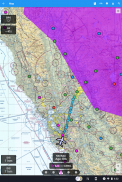
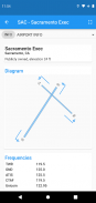
항공 탐색이 간편하고 저렴해졌습니다. 미국 본토에 대한 모든 VFR, 저고도 IFR 및 계기 접근 차트(항로 항행 지원을 포함하여 완전한 비행 계획 포함). Nexrad, METAR 및 AIRMETS/SIGMETS에 대한 오버레이는 비행 안전을 개선하고 자세한 공항 정보(활주로, 주파수, 연료, 날씨)를 손쉽게 이용할 수 있습니다.
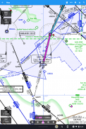
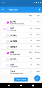
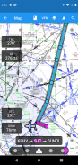
이동 지도를 사용하여 공항, VOR, NDB 또는 교차로를 검색하거나 선택하고 직접 탐색을 시작하거나 비행 계획에 추가합니다. 또는 텍스트로 비행 계획을 입력하십시오(예: KPAO SUNOL V334 SAC KSAC는 모든 항로 항법 지점을 포함하여 전체 비행 계획을 로드합니다.
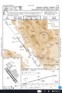
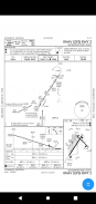
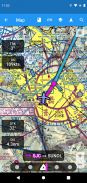
계기 접근 차트에는 공항 도표, STARS, DP 및 최소값과 범례가 포함됩니다.
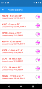
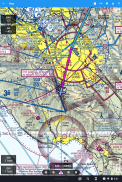
주변 공항은 녹색 또는 빨간색으로 표시되어 해당 공항이 바람 없는 활주로에 도달할 수 있는지 여부를 나타냅니다.
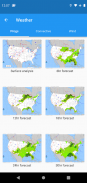
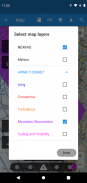
METAR, TAF, AIRMET, SIGMET, Prog 차트, Convective Outlook 및 Wind는 그래픽 및/또는 텍스트 정보로 사용할 수 있습니다. METAR 및 AIRMETS/SIGMETS는 레이어 버튼을 사용하여 지도에 오버레이할 수 있습니다. 공항 정보는 일반 영어로 METAR 및 TAF를 표시하고 다른 시간 및 고도에 대한 Prog 차트, Convective Outlook 및 Wind 그래픽은 전체 화면 그래픽으로 사용할 수 있습니다.
AviNavi는 무료 평가판 기간 후에 월간 또는 연간 구독이 필요합니다.
AviNavi, navigation for pilots - 버전 4.5.7
(08-01-2024)뭐가 새롭나Improved NEXRAD image type and presentation

AviNavi, navigation for pilots - APK 정보
APK 버전: 4.5.7패키지: com.bbflight.avinavi이름: AviNavi, navigation for pilots크기: 29 MB다운로드: 158버전 : 4.5.7출시 날짜: 2024-05-21 10:58:00최소 스크린: SMALL지원되는 CPU:
패키지 ID: com.bbflight.avinaviSHA1 서명: 19:D0:E8:1C:B4:A4:B0:24:CA:C8:43:2E:51:69:55:00:83:73:2E:B0개발자 (CN): 단체 (O): BBFlight LLC로컬 (L): 나라 (C): 주/시 (ST): 패키지 ID: com.bbflight.avinaviSHA1 서명: 19:D0:E8:1C:B4:A4:B0:24:CA:C8:43:2E:51:69:55:00:83:73:2E:B0개발자 (CN): 단체 (O): BBFlight LLC로컬 (L): 나라 (C): 주/시 (ST):
AviNavi, navigation for pilots의 최신 버전
4.5.7
8/1/2024158 다운로드2.5 MB 크기
다른 버전들
4.5.5
3/9/2023158 다운로드2.5 MB 크기
4.5.4
4/2/2023158 다운로드2.5 MB 크기
4.4.0
7/12/2022158 다운로드2 MB 크기
3.3.2
29/1/2021158 다운로드6.5 MB 크기


동일 카테고리의 앱


English


